I’ve been doing some research on the island’s geography—the way it looked back when America was founded, the way it looks today, and how it got there. In this post, I’m just going to hit a few of the highlights that I find most interesting and link to the sources of information. I highly encourage anyone interested in the island’s history to check out the linked resources.
Pleasure Island hasn’t always been an island. This alone was surprising. The area was originally known as Federal Point—a peninsula. In fact, the entire area from Silver Lake and Myrtle Grove, down to Fort Fisher, is still officially referred to as the Federal Point Township for statistical purposes. The island was created in 1931 when the U.S. Army Corps of Engineers completed cutting a channel stretching from the Cape Fear River to the Atlantic Intracoastal Waterway. This channel became known as Snow’s Cut. It’s the body of water we cross on the bridge over to Carolina Beach. If you ever have the privilege of being a passenger in a vehicle while crossing Snow’s Cut Bridge, you can see both ends of the channel and awe at the 1930’s engineering that created it. Please don’t try this while driving!
Pleasure Island hasn’t always been called ‘Pleasure Island’. The name was coined in 1972 by the Chamber of Commerce as a marketing tool for promoting Carolina Beach, Kure Beach, Wilmington Beach, Hanby Beach, and Fort Fisher. The name stuck. Whatever happened to Wilmington Beach and Hanby Beach? These two areas were situated between Carolina Beach and Kure Beach. In 2000, Wilmington Beach was annexed and became part of Carolina Beach. The Hanby Beach area is now part of Kure Beach.
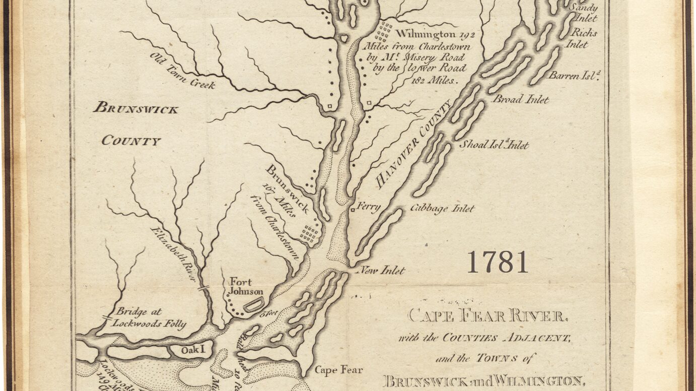
Bald Head Island used to be part of the Federal Point peninsula. Then it became an island. A storm in 1761 created an opening between what is known today as Fort Fisher and Bald Head Island. This became known as New Inlet. It provided an alternate route to the Cape Fear River. What we know as Bald Head Island today was known as Smith Island back then. Some people may occasionally still refer to it as Smith Island. Fort Fisher was originally built to defend the port of Wilmington from enemy vessels coming in through this ‘new inlet’ and coming up the Cape Fear River.
Then Bald Head Island became connected to Pleasure Island. In 1998, Hurricane Bonnie shoaled and closed the inlet, once again uniting Bald Head Island and Pleasure Island. It’s now possible to walk from Fort Fisher to Bald Head Island.
The Intracoastal Waterway hasn’t always existed. The Intracoastal Waterway stretches for 3,000 miles from Boston, around Florida, and over to Brownsville, Texas. The Army Corps of Engineers created a protected channel for inland shipping by dredging rivers, bays, and sounds. The aforementioned Snow’s Cut is part of that. A section of Masonboro Sound was dredged for this project also. So, the entire water area between Masonboro Island and the mainland is the Masonboro Sound, but only a section of it is technically the Intracoastal Waterway. The waterway specifies a channel that is at least 12 feet deep and 125 feet wide that can be used for shipping.
The North End hasn’t always been the north end. What we call Pleasure Island today was connected to what we now call Masonboro Island back when the area was called the Federal Point peninsula. Local fishermen wanted a shorter route to the sea and took it up on themselves in 1952 to blast this inlet into existence. The flood of water caused much more erosion and made the channel much wider than they expected. Today, we call this the Carolina Beach Inlet. By the way, the person who headed up the creation of the inlet was Carl Winner, a prominent sea captain in the area. That’s the same Carl Winner that Carl Winner Drive by the south side of the yacht basin was named for.
The Carolina Beach Yacht Basin was part of Masonboro Sound. I haven’t seen this explicitly stated anywhere, but based on 1800s maps, it appears to me that the Masonboro Sound was a single body of water that stretched from Masonboro Inlet down to the modern-day Carolina Beach Yacht Basin. At some point, the southern tip of this sound became known as Myrtle Grove Sound. In 1939, part of the Myrtle Grove Sound was dredged to form what is today the Carolina Beach Yacht Basin. The previously mentioned Carolina Beach Inlet was created to provide a short route for fishing boats from the yacht basin to the Atlantic Ocean. Prior to this, boats had to go south through the Cape Fear River, or north to Masonboro Inlet.
Articles I’ve found helpful. To learn more about the fascinating history of Carolina Beach and Pleasure Island, I highly recommend these articles:
- Carolina Beach Historic Highlights Timeline
- A Layman’s Unofficial History of Carolina Beach
- Pleasure Island, NC on Wikipedia
- Wilmington Through the Lens of Louis T. Moore – Federal Point
How do you think the island might change over the next 25, 50, or 100 years?
If you grew up here and have corrections, additions, or stories connected to any of this, I’d love to hear from you.
Original Image from Wikipedia. Deed – Attribution 2.0 Generic – Creative Commons